The 20th Century’s Most Complex Forensic Investigation

Human remains line the walls from floor to ceiling at the Podrinje Identification Project (PIP). PIP is one of three of the International Commission on Missing Person’s (ICMP) facilities, and one of two that deals directly with the human remains related to the fall of Srebrenica. The ICMP was founded in 1996 by President Clinton to address the issue of missing persons from the former federal republic of Yugoslavia, and its extenuating conflicts from 1991 to 1995. Thus far, over 70% of the victims that went missing from these conflicts have been accounted for. ICMP has worked alongside governments in the region to accurately identify 16,722 persons, of which 13,964 relate to the conflicts in Bosnia and Herzegovina. The numbers, particularly those related to Srebrenica are staggering, and fail to bring justice to the havoc that was wrecked on this once harmonious, and diverse region.

Srebrenica represents one of the most complex and comprehensive forensic investigations of the 20th century. It has taken over twenty years to find 90% of the estimated 8,0000 victims, and those that have been found were scattered across a territory spanning 2,800 square kilometers. The most complicated forensic challenge has come in the form of locating and identifying the victims. The initial mass graves, also known as primary graves, were unearthed and the bodies were removed and buried in a series of secondary sites in an attempt to conceal evidence. As a result, body parts are scattered throughout multiple sites. Body remains have been found at up to four different sites.

The ICMP was initially utilizing a traditional forensic method of identification for these bodies, however, it became increasingly evident that this method had its limitations. The arduous process of identifying victims of the conflicts warranted techniques that weren’t yet available. The ICMP developed DNA identification in order to more conclusively identify the remains. This is done by taking DNA profiles from blood samples of family members with missing relatives. The DNA profiles are then analyzed and compared, and the bodies are identified. In one instance, a woman came in for a blood sample in hopes of identifying her son who was presumed dead in Srebrenica. The ICMP was able to find a match to her blood, but it was deemed too old by traditional forensic investigation to match the profile of her son. Further investigation revealed the match to be her father who was killed in WW2 alongside the river Drina in Eastern Bosnia.

The ICMP is uniquely indebted to one individual for his tireless assistance in finding the remains of Srebrenica victims. Ramiz Nukic scours the hillsides near his birth home in Kamenize, eastern Bosnia day after day in search of human remains. He has no job, but feels that it is his moral duty to help the ICMP in their identification process. Since 1999 when he began his search (in hopes of finding his father and brother), he has brought countless families closure by finding their loved ones in this tragically beautiful countryside. He recalls the day that he fled from Srebrenica, and hardly recognized his own home, because the hillside surrounding it was covered with the dead. Each time he discovers bones he contacts the ICMP who then take away the remains to be identified through DNA analysis. He stated “I feel bad when I don’t find a bone…. But am happy when I do. Because one family will find closure.” The ICMP found the body of his father this year, and he was able to bury him at the Srebrenica memorial on July 11.

Ramiz Nukic and Hasan Hasanović in Kamenize

Ramiz Nukic and Hasan Hasanović in Kamenize

Since its inception nearly two centuries ago, the ICMP has become the world’s leading authority on missing people. Its headquarters have been transferred from Sarajevo to the Hague to become a permanent global body. The techniques pioneered at the ICMP have helped identify victims of natural disasters, political repression, drug crime, apartheid and war. Countries where it has proven successful have been in Thailand, the Philippines, Chile, South Africa, the United States, Iraq, Colombia and Libya. The ICMP provides some degree of consolation for the widespread deaths that occurred in Bosnia and Herzegovina by bringing families unrequited solace and closure. Upon entering the PIP headquarters, you’re overcome by a sense of helplessness when confronted with the scope and complexity of those missing. In the short amount of time we were able to spend with Ramiz Nukic, it was amazing to see how one individual was able to overcome such a daunting physical and mental mission. His tireless pursuit and humility have been integral to the success of the ICMP, but more importantly, have called those directly and indirectly involved in the Srebrenica genocide to redefine how they choose to deal with and confront loss.
IMG_8787

Reviving Srebrenica

The town of Srebrenica teeters on the brink of existence. It was once an affluent place, known for its metal factory and large spa. Nowadays, its streets resonate with emptiness and despair. Bosnians are quick to advise you not to visit, saying something along the lines of “don’t go there, the place is empty.” Srebrenica is now infamous for being the site of the worst atrocity on European soil since World War II. July 11th marked the twentieth anniversary of the genocide.

PeaceMarch

The many faces of Srebrenica at the end of the march.

In attempt to pay homage to those mercilessly killed, we took part in the Mars Mira, or March of Peace. We set out in the village of Nezuk alongside 10,000 others, and ended in Potočari. The march commemorates the 15,000 men who fled to Tuzla in hopes of escaping Serbian persecution after the fall of the Srebrenica enclave on July 11, 1995. The predominantly Bosniak area of Central Podrinje was of strategic importance to the Serbs, because without it, there would be no territorial stronghold within their new political entity, the Republica Srpska. Hence, it was in Central Podrinje, and other parts of Eastern Bosnia where the Serbs proceeded with systematic ethnic cleansing of Bosniaks. The Mars Mira is made in reverse order, and ends in Potočari, at the site of the former Dutch “safe zone.” The “safe zone” fell when the Dutchbat were unable to reinforce their batallion and deter the relentless Bosnian Serb attacks. Today, a large memorial is located across the street from the safe zone, and at the end of the march bodies are laid to rest that have been identified that year. According to the International Commission on Missing Persons, 6,930 bodies have been identified from 17,000 body parts found in dozens of mass graves. However, 1,000 victims from the massacre have yet to be identified. This year, there were 136 burials of newly identified bodies.

The genocide that took place at Srebrenica represents the largest DNA-identification project ever conducted, and provides unfaltering proof of the massive atrocity. Despite this, many people claim it never happened. The official ruling of Srebrenica was highly complex and took years to complete. It began with just two detectives from Croatia, who knew nothing about the area, or the extent of the events. They stated that it was like trying to extract diamonds form a coalmine to obtain the best witnesses from a complex web of information. Like Rwanda, it became increasingly apparent that the killings had been systematically planned, indicating that the cases should be treated as genocide. Eventually, Judge Theodor Meron ruled on behalf of the International Criminal Tribunal for the former Yugoslavia ruled that “among the grievous crimes this Tribunal has the duty to punish, the crime of genocide is singled out for special condemnation and opprobrium. The crime is horrific in its scope; its perpetrators identify entire human groups for extinction. Those who devise and implement genocide seek to deprive humanity of the manifold richness its nationalities, races, ethnicities and religions provide. This is a crime against all of humankind, its harm being felt not only by the group targeted for destruction, but by all of humanity.”

The Peace March was a test of physical and mental resolve, and a humbling experience to say the least. Emotions ebbed and flowed over the course of the three days, ranging from a tremendous hope in humanity to an incredible anguish. People came from all corners of the world to participate in the march, some with direct connections to those killed, others who fled Bosnia, and others simply because they had a deep love for the country. Their individual stories enriched the journey, and provided unique perspectives.

The memorial was an overflowing of international dignitaries. Back in Srebrenica, the town had been transformed into a bustling city. Cevapi stands lined the streets, the highway overflowed with cars and buses, and people opened up their homes to accommodate the mass of walkers, and dignitaries. We remained in Srebrenica the day after the memorial, and awoke to a desolate city. A few photographers and journalists remained in the local coffee shop, making final edits on their work before sending it off to their agencies. It served as an eerie reminder of Srebrenica’s future. Hassan Hasanović, the curator of the memorial, and a survivor of the march, accompanied us for most of the weekend, and in an interview with the BBC made the plea “the whole world should show that there is life here after the deaths. We need to persuade people to invest here and have their future here, especially the young people. If young people leave, Srebrenica will die. So my question is – does the world want Srebrenica to die again?”


Sarajevo: A Meeting of Coffee Cultures

The history of Bosnia is very much intertwined with the history of coffee. The Bosnians were by no means pioneers in the coffee movement, however, their geographic location placed them at an ideal crossroads to incorporate coffee consumption as a meaningful daily activity. My first impressions of Bosnia came when we crossed the border from Croatia to meet up with our Bosnian tour guide, Faruk. Faruk insisted the most important thing we do before exploring his country was to get to know each other over a cup of coffee. imagesWe marveled as he managed to make an espresso last over an hour. While slowly sipping, he explained the importance of coffee, and the role it has accorded in most Bosnians lives.

Once outside Africa, coffee beans were utilized and quickly spread throughout the Ottoman Empire in the 16th century. Shortly after, when the Austrians defeated the Turks in the Battle of Vienna, it was discovered that the Turks leftover spoils were in fact coffee beans. The Austrian officer who received the spoils used them in Vienna’s first coffee house. He helped make the coffee more palatable by adding sugar and milk to the acidic coffee.imgres Bosnia, whose history is uniquely indebted to both countries, has assumed their own identity that is a delicate balance of East and West. Strolling through the old town, you walk across a compass with two directions: East and West. The compass symbolizes the country’s tug-of-war between the Ottoman Empire and the Austro-Hungarians, and how despite the pull of both empires, Bosnia managed to emerge as their own unique entity.

Our first cup of coffee drew to a close, and Faruk used the dwindling time to discuss – what else – Starbucks. He remained baffled by the company’s success. Why would someone enjoy being corralled into a line only to be served a large, syrupy coffee only to leave 10 minutes later with very limited interaction? Coffee, he said is meant to be shared, and is an opportunity to spend time with loved ones. Coffee is a special opportunity to cherish time with one another, and you never know if you’ll see someone again.. It’s a common quip that in Bosnia happiness is not measured by the amount of wealth you have, but by the number of close friends you have. Coffee is merely an excuse to enrich these relationships. img_2294-0

Antipodean Adventure

Precariously perched at the edge of the world, New Zealand is bareley crammed into our country-centric worldview. As such, it is considered our antipode, and it’s inhabitants antipodeans. An antipode literally means “opposed, foot”, and in geography it is the place on the earth’s surface that is most diametrically opposed to another point on the earth’s surface. In the Northern Hemisphere many assume Middle Earth, ahem New Zealand to be their antipode. However, Spain is the North Island’s true antipode. In case you need reminding just how far away you are, there’s even a group of islands off the coast of New Zealand known as the Antipodes Islands. Despite being one of the last places in the world to be settled by humans, New Zealand was the first to grant women the right to vote, and also preserve its land as part of a national park. Its remoteness and small population have been its saving grace, and today both the North and South Island offer some of the world’s most unique and pristine landscapes. You’d be hard pressed to find a less than comely corner of this country, so whatever trail you set out to tramp, helicopter, bungee, paraglide, 4-wheel, or surf, expect it to be awe-inspiring.
As my plane descended into Auckland I was struck by the spectacular views outside my window. A narrow strip of land separated the turquoise-hued Tasman and Pacific, and just beyond their near convergence were countless undulating volcanic peaks. I quickly took out my camera to start snapping photos, only to be interrupted by the man beside me “First time to New Zealand?” I responded “yes” before he continued, “You’ll love it here. It’s the most beautiful country I’ve ever seen.” Well, I thought, I haven’t even landed in this country and already I have some rather lofty expectations.
I arrived in New Zealand by way of Indonesia, and met up with my parents and brother who flew in from Colorado and Montana. After a fuel leak on their end, and being re-routed through Hawaii and Fiji, we reassembled in Auckland, the airport offering the best range of international flights, and the most convenient place to being our North and South Island campervan tour. Before picking up our boxy camper (particularly considering New Zealands narrow roads and numerous one-lane bridges), we hopped on and off the Auckland explorer bus for an abbreviated city tour, and took in a Maori cultural show at the Auckland Museum. We all found ourselves remarking about the similarities between Auckland (and later Wellington) and the cities along America’s pacific coast, starting with San Francisco all the way up to Vancouver. Perhaps this could be attributed to the colonization in the wake of Captain Cook’s Pacific explorations, or simply the appeal of the Pacific. Later, when we went to pick up our RV, we bypassed countless rows of nondescript white campervans, only to be given the lots most prized campervan, the ”Crazy About Rugby” mobile. For whatever reason, the Maori gods were smiling on us and for the next two weeks we happily pledged our allegiance to the All Blacks (and in the process made a lot of kiwi friends).

''Crazy About Rugby"

”Crazy About Rugby”


Rotorura was our first stop south of Auckland, luring us with its hotbed of geothermal activity. Before we even reached the main street of town, there was a distinctive sulfur scent in the air. Some call Rotorura “Roto-Vegas” given its commercialized tourism, which in my opinion is a big stretch. If this was New Zealand’s version of Vegas, it only made the country that much more endearing. The main center for tourism in town is Te Puia, a Pacific inspired building offering tourists anything from hanji feasts, Maori performances, geyser tours, etc. One could idle hours away just in their gift shop, which we nearly did, but before long daylight was fading and we had yet to find our first campsite. After a few wrong turns up farming roads, we arrived near dusk at the Blue and Green Lakes campsite just Southeast of Rotorura. I rose early the following morning for a run along Blue Lake, just as the sun was stretching its way across the lake and through the trees. On my return trip, I plunged into the refreshing and aptly named blue lake, thereby initiating my baptism into the kiwi lifestyle.IMG_0049
Eager for more Volcanic activity, we pressed on towards the Tapuo volcanic zone, a tumultuous region spanning from Rotorura over to the Bay of Plenty. En route, we passed by New Zealand’s largest lake, Lake Taupo, which looks to be more like an ocean than a lake and sits in the middle of a volcanic caldera. Wrapping our way along the lake we marveled at the many modern lakefront properties, before starting the climb to Tongariro National Park. Tongariro National Park is New Zealand’s first national park, and the world’s fourth, and boasts three impressive mountains. Mt Rupaehu is the mountain that first sparked the climbing interest of one of New Zealand’s most beloved countrymen, Sir Edmund Hillary. Mount Ngauruhoe, which is better known as Mt. Doom from the Lord of the Rings. We chose to climb the third, Mt Tongariro, since it wasn’t as foreboding as Mt. Doom, and our fitness levels weren’t quite Sir Edmunds caliber. It’s recommended that you hike the Tongariro Alpine Crossing by starting at the lower parking lot, crossing over the top and then sleeping and walking back the next day or catching alternative transportation on the other side. Since we already had accommodation in our camper, we chose to hike to the top and then turn around, which ended up being a 12-mile hike. The higher you climb, the more picturesque the landscape becomes. The hike began in a vast, barren landscape on a well-maintained trail across a lava field, and then traversed up the spine of the mountains. The top was scrappy, but well worth the panoramic views. In one direction clouds hovered over Mt. Doom, to the west were three milky-blue pools and a caldera on the horizon. Once we reached the bottom we rewarded ourselves with a tasty, massive meal of lamb shanks at Schnapps pub in National Park Village.
The last stop we made on the North Island was its most southwestern point, New Zealand’s capital city of Wellington. I’m still trying to wrap my head around how unexpectedly awesome this city was. It may be small, but that didn’t stop it from packing a lot of punch, well deserving of its title “coolest little capital in the world.” We arrived in Wellington the day school finished for the semester, so the city was awash with academic relief, excitement and high spirits. Everyone was fashionably clad, and enjoying themselves with celebratory beers and wine along the waterfront. The warf area, which has recently undergone a series of renovations, is the real draw of the city. It is chock-a-block with fun bars and restaurants, museums, and public artwork (keep your head up as some of the coolest is floating overhead). Further down the waterfront is the colossal Te Papa museum. It is approximately the size of three football fields, with every square impeccably well curated. Highlights include an outside bush walk displaying New Zealand’s native flora and fauna, and inside an interactive house that shakes as though you are experiencing an earthquake. Make sure to also visit the exhibition on the Pacific and New Zealand history. The only drawback of life in ”Windy Welly” is the powerful wind that barrels through (it’s been known to tip over ships). If you’relooking for a scenic camping spot I’d recommend not sleeping at the downtown Holiday Park. We decided to stay in the city so we could catch the Cook Strait Ferry the following morning, and they ended up corralling us onto a big swatch of pavement jammed together with our closest camper friends. Nonetheless, I enjoyed walking around the city’s downtown in my pajamas alongside women in high heels and flouncy dresses.
Although the Cook Strait is known for its choppy waters and is mandatory for anyone wanting to take their car or cattle from one island to the other, it’s a very pleasant trip. Head to the upper deck in warm weather, and you’ll take in views that are almost, but not quite as jaw dropping as those in Fiordland. Once we were off the ferry, we headed straight to Kaikoura to consume and commune with the sea life. En route, we stopped off at the surfside Nin’s Bins, where we tasted our first ever crayfish. The place is no frills, but what you’ll get is some of the freshest, tastiest crayfish in town (the business has been in the family for three generations-which is just about as far back as you can go for Kiwis). Just up the road, we made another stop to see a cluster of New Zealand fur seals lounging on the rocks, while Albatross circled overhead. Unfortunately our weather was extremely overcast the following day, so we weren’t able to spot any whales or dolphins, but fortunately, the farmers market was open. The market was quaint but offered a range of fresh produce, and some excellent cheese from the Gibbston Valley. Nins BinsIMG_0040
For our next leg of the trip, we decided to venture off onto a road less traveled. A perennial New Zealand visitor advised us to travel through Hanmer Springs, rather than continue south to the city on the mend, Christchurch. Hanmer Springs is a little oasis located in the middle of nowhere, but a nice place to revive tired tramping limbs. We soaked ourselves in the Hanmer Hot Springs before venturing across the Lewis Pass Highway to Westport. Once on the Westcoast, a region famed for its limestone and mining (for more on this, I’d highly recommend The Luminaries), we merged onto the scenic SH 6, or Coast Road to the Pancake Rocks at Punakiki. It was a spectacularly serpentine road, and one not intended for the faint of heart. Steep cliffs drop down into large bays on one side, and on the other side are the densely wooded Papora Ranges. The Pancake Rocks are one of the more bizarre formations I’ve seen (I’d put them up there with hoodoos at Bryce Canyon), but fascinating nonetheless. Just on the horizon, we caught a mother whale milking her baby.
Still anxious to take in the other highlights of the Westcoast, the Fox and Franz Joseph glaciers, we headed south. In Fox and Franz Josef, natural wonders collide: rainforest, ocean and glaciers. In any other environment it wouldn’t seem possible that such landscapes could exist side by side, but given the West Coast’s plentiful rainfall they manage to here. The rainfall makes for an incredibly lush and verdant landscape, but one that is not well suited for glacial climbing. The Maori’s name for the Franz Josef Glacier is Tears of the Avalanche Girl, which seems more appropriate than that of a deceased Austrian emperor. It is said that after the woman’s lover fell from the nearby cliffs, her tears froze to form the glacier. In the conditions that we visited the glacier, it would appear that the woman is still distraught. Thankfully, there are cautionary park signs cleverly illustrating what will happen if you attempt glacial climbing in less than perfect conditions. We made it to the base of the glacier where we took the standard tourist photo, and quickly turned back. Later in the day we took a walked around Lake Matheson, but the inclement weather hadn’t subsided so we missed the rumored beautiful reflection of Mt. Cook. We reconciled our losses for the day and headed into town for warm drinks in one of the town’s many cozy coffee shops.
Prior to our trip to New Zealand, we were told that the South Island was markedly different and more beautiful than the North Island. We found the latter hard to believe since the North Island was imbued with so much beauty. However, once we reached the last legs of our trip, Queenstown and Milford Sound, we too, found ourselves partial to the South island. Like most of New Zealand, Queenstown is geographically blessed. It’s situated at the edge of glistening Lake Wakatipu and the base of the jagged Remarkables. It’s a resort town, but one where you can still carve out intimate spaces away from the tourist hubbub. If crowds don’t bother you, then grab a Fergberger and head to the gorge north of town for AJ Hackett bungy jumping. There is good reason for the popularity of these two Queenstown institutions. Sure you’ll have to wait in a long queue at Fergberger, but the burgers ooze with flavor, and because each burger is so big it’ll last you long enough to wait in the queue to sample another (my personal favorite is the Tropical Swine). We stopped by the AJ Hackett bungy site as part of a day trip, and not only is the bungy jump the first in the world, I’d wager it’s also the most scenic. After watching countless daredevils bounce back up (some after plunging into the waters below), we continued on our way to Arrowtown and the wineries flanking the Gibbston Valley. Arrowtown is a town that sprung up in the 1860s after the discovery of gold, and its historical ambience is something that you’d expect to find on the set of a Western movie. For a bit of history and discriminatory conditions the Chinese endured there during the NZ gold rushes, visit the Chinese settlement by the Arrow River. Just beyond the settlement is a network of great hiking trails.
View of the original bungy

View of the original bungy


Milford Sound is the place where our trip culminated, and I can’t imagine a better parting memory of New Zealand. Once called the “eighth world wonder,” by Rudyard Kipling, the place abounds with untouched beauty. Its u-shaped glacial valleys are framed by towering, sculpted peaks. According to Maori legend a warrior came through Fiordland hacking his machete in broad swaths, cutting away the landscape, leaving the fjords. By the time he perfected his wielding of the machete, he had carved out the area of Milford Sound. There is a range of Milford Sound tours offerd, with most beginning in Te Anu or Queenstown, offering transport by bus , airplane or helicopter. We booked our tour through Rail Journeys in Queenstown, and opted for the bus and overnight on board the boat (my family previously took a trip on Halong Bay, Vietnam and loved the experience of waking up in such a tranquil environment so we figured we’d try it again). The last half of the bus ride was almost as spectacular as the actual fjord, with the bus lurching deep into the Hollyford Valley, and upwards through the single-lane Homer tunnel. At the foot of the sprawling mountains were fields of chest-high wildflowers, and rivers so clean that we drank from them. The road and mountainside were scarred in places from the frequent landslides and avalanches that periodically block access to the fiord.
Before we even left New Zealand, we were already planning our next trip there. Talking with different travelers throughout our journey, it became apparent that there’s no one perfect route of the North and South Islands; any way you go is spectacular. In my limited attempt to describe what we saw, I managed to exhaust the synonyms I have in my vocabulary for beautiful, stunning, and scenic. All fall short of capturing the magic of New Zealand. Its unspoiled nature is a tonic capable of absolving any worldly problems.

Oh, Inverted World!

Australia is a country that is cunningly familiar to most visitors. Let your mind wander for a few minutes while there, and you’ll probably be reminded of a place you’ve been before, or even a variety of places. Then a kangaroo hops by, the swans are black, and the trees are shedding their bark. Once you recognize the idiosyncrasies of the world’s largest island you fully begin to understand the marvel that is Australia. It has been isolated from the other continents for over 45 million years, and as a result its birds, plants, and mammals are some of the world’s most distinct, diverse and deadly. Its isolation has also left Australia without predators or parasites that are common in other parts of the world, so when introducing a native species that thrived elsewhere, it can gravely upset Australia’s fragile balance of life. A prime example occurred when Thomas Austin introduced 24 wild rabbits from England to Australia for sport hunting. Before long they multiplied to over 300 million rabbits devastating thousands of acres of cropland and transforming the landscape of modern-day Australia. There is a marked English and American influence on Australia, and in the past, people sought to model it after one or the other, but Australia is vehemently Australian. So, while there you best set aside your tea and scones for a flat white and a piece of toast with some vegemite. Get out your polymer notes, and saddle up at the bar next to your new best mate. After knocking back a few cold ones, you’ll be wishing your country also had convict beginnings.
The most important experience to have on a first trip to Australia (next to sharing a beer with a new mate) is to get a sense of just how dry, flat, and large the country is. The heart of Australia, which in earlier times was fondly described as the “ghastly blank” may be home to less than 10% of its population, but that’s what makes it all the more special. Its vast frontier cultivated the ethos of Australia’s most beloved personalities: the swagman, squatters, and bushrangers. Today’s outback residents are no less hearty than their predecessors, and put up with daily stinging ant battles and other minor nuisances like nuclear testing, extreme droughts and no gas for 1200 miles. The outback is fraught with countless tales of attempted, and failed exploration; men vanishing into oblivion or returning home with missing appendages, loss of sight and covered in blisters and lesions. Fascinating tales that spark the imagination and cause a person to wonder what in the world could be out there. Some thought there were mighty river systems or an inland sea, but in 1873 it was finally confirmed what was out there. A massive rock! Or, more geographically appropriate, a monolith- known to some as Ayers Rock, and to others more affectionately as Uluru. For 2500 miles north and south, and 2000 miles east and west it’s the prize of the interior.
The first time I landed in Perth I was overcome with a vague sense of alienation. Not a panicked sense of alienation, more a sense of wonder over its overwhelming loneliness. I’ve been to the world’s two most isolated capital cities, Honolulu and Wellington, and although difficult to access, civilization was still nearby. Perth, on the other hand is isolated in all four directions for at least 1500 miles. My flight from Perth to Sydney didn’t do much to dispel the feeling of being in the middle of nowhere. The flight is similar to flying from San Francisco to New York- less one hour, but because there is literally nothing below you save for some dingoes, you feel like a hole has been ripped in the space/time vortex. Just when you think life ceases to exist, Sydney emerges like a mirage on the horizon.


One of the things that I love about Aussies is that they never tire of inciting the friendly argument with each other over which city is better, Melbourne or Sydney. This playful banter dates back to the days of the 1850s gold rush when both cities rose to prominence. Each hoped to become Australia’s largest, richest and capital city. They were so closely matched that in a spirit of joint cooperation, they decided a new capital would have to be formed in between to placate the Melbournians and Sydney-siders. Enter Canberra, which today enjoys the most attention as the answer to the geography trivia question of what is the capital of Australia. Even though Australians went to great pain to partition out new land for the capital territory, they couldn’t keep Melbourne and Sydney from continuing to evolve into much more flourishing, and dynamic cities than pedestrian Canberra. Not much has changed since the 1850s, as today both cities remain the largest (both on the verge of 5 million), richest, and still not the country’s capital. But, year after year they have been recognized as ranking in the top tier of the world’s most livable cities. They boast an impressive resume of good healthcare, education, infrastructure and a burgeoning cultural scene. Did I mention that their food is also surprisingly tasty? It’s a far cry from its bland British culinary beginnings, and today is a nice fusion of Eastern and Western palates.
Since Sydney was the first city I visited of the two, I have a certain partiality to it. One can’t help but fall victim to its beguiling harbor front with every bend affording a new perspective of the city. Many thanks are due to the former governor of New South Wales, Lachlan Macquarie, who some have equated to Australia’s Abraham Lincoln. Impressed with a name of such integrity, Australians took great liberty in naming just about everything imaginable after him: Port Macquarie, Mrs. Macquarie’s chair, Macquarie University, and even Macquarie island. Under him, the primitive city of convicts was transformed. Macquarie gave the convicts opportunities to earn their freedom by working on various projects around the city- roads, bridges, wharves, and other public buildings. Today, the projects still stand as impressive architectural monuments. They helped establish a unified aesthetic in the city, and paved the way for other architectural feats, notably the Queen Victoria Building, the Harbor Bridge, and world-renowned Sydney Opera house. When you tire of all things related to Macquarie, fret not, because the governor who succeeded him, Ralph Darling, also has an impressive list of places named after him. My favorite is Darling Harbor. The harbor is located in the former docklands, and is now a buzzing tourist snare full of fountains, public art and hip restaurants.
We arrived in Melbourne the day before New Years, and were unable to capture the true character of the city. There was an influx of out-of-towners, and the typical day-to-day rhythm of the city had been interrupted by the holiday. We stayed at the Rendezvous Grand Hotel, which was perfectly situated- adjacent to Federation Square, and a stones throw from the recently renovated Southbank area. Just outside our hotel arose a wonderful juxtaposition of modern buildings and 19th and 20th century buildings. Given the ridiculous driving laws in Melbourne (the hook turn- ‘right turn from left only’), and our prime location, we chose to walk just about anywhere we could. Once we crossed over the main artery of the city, The Yarra River, we made our way to the Royal Botanic Gardens. The Gardens were a sight to behold, and are some of the finest I’ve had the pleasure of visiting. After reluctantly leaving the gardens, we made our way to the National Gallery. Again, another place I could go on gushing about. The thinly veiled exterior water wall was just the beginning, and I enjoyed that I didn’t leave there with an aesthetic headache. Because it was such a pedestrian-friendly city, we continued on towards the alleys and arcades that were teeming with festively clad partygoers the previous evening. When vacated, they provided a nice opportunity for us to take in Melbourne’s many vibrant, swirling mosaics. This city was clearly overflowing with a lot of creative juices. It’s a shame we arrived when it was in such a state of flux, but I guess that just means we’ll have to return some other time. For now, we had to move on to the Great Ocean Road.
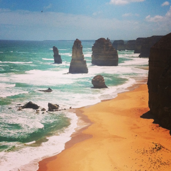
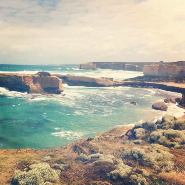
The Great Ocean Road is a spectacular stretch of highway that snakes its way along the scenic Victorian coast southwest of Melbourne. On one side are deep, turquoise bays, and on the other are the steep and forested Otway Ranges. The drive culminates close to Port Campbell, where the twelve apostles now reduced to eight by the pounding sea congregate and the London Bridge (today named the London Stacks) falls. It is a spectacular sight when the sun illuminates the limestone and transforms them into sparkling golden formations. It’s quickly apparent that a lot of powerful winds and tides were at work in creating such a unique coastline. The Great Ocean Road overlaps with a section of the Shipwreck coast, the site of over 1200 shipwrecks. If you’re not in a rush to beat the traffic while on the road, make sure to read the signs documenting all the different crashes. On another morbid note, the Great Ocean road is also the world’s largest war memorial. Over the course of 12 years, it was built by, and dedicated to solders killed in WWI. If you want to see the Great Ocean Road around the Christmas and New Years holiday, which occur during the nicest midsummer months, make sure to plan in advance because of the crowds. We booked our vacation months out and ended up staying in Lorne because all the other towns along the road were booked to capacity. Inside the trailer parks, people were packed together like sardines. Lorne ended up being a charming little town, and I imagine it is even lovelier when not overrun with holiday hordes. IMG_0545
IMG_0546
After the Victorian Coast, we hopped on a Virgin Australia flight to the top of Queensland, where we discovered Captain Cook’s favorite corner of the continent. Prior to his discovery of Botany Bay and Sydney Harbor, Captain Cook’s ship lodged on some coral in the Great Barrier Reef, and nearly sank. One of the men abroad his ship was able to perform a new technique known as fothering, where he wrapped the boat in its sails to prevent any more water from coming in, and then brought the boat ashore for repairs. While waiting for the ship to be repaired, a disheartened Captain Cook named the surrounding areas (the names were in no way were indicative of his typical, happy disposition): Mount Sorrow, Weary Bay, Endeavor Reef and where he almost lost his ship, Cape Tribulation. We stayed just south of Cape Tribulation, in a charming town called Port Douglas. Like Cape Tribulation, Port Douglas is also known for trouble that took place just offshore (I’m sensing a theme here), where Steve Irwin was killed when a stingray barb pierced his heart. It also happens to be the place where Bill Clinton was on vacation when he found out about the September 11 attacks. Its best to leave these stories in the shadow of Mt. Sorrow, since both places are spectacularly verdant, lush and offer the best of Australian tourism. Port Douglas is the place where national historic sites come full circle, and you have your choice of the crème de la crème of rainforests or reefs. Granted, it’ll come at a price. We paid $150- $200 for each tour, but they were all well done. I would highly recommend Tony’s Tropical Tours for the Daintree Forest and Mosman Gorge, and Poseidon tours for snorkeling or diving the Great Barrier Reef. The guides were incredibly knowledgeable, and after spending fifteen minutes in the rainforest and at sea with them, we were made aware of ways to be ruthlessly kicked to death by a cassowary, impaled by a stinging, flesh-eating leaf, poisoned by a plum, stung by a jellyfish, or just your standard shark attack. The tours were definite highlights of our trip, but after returning from them, I was quite content to relax in the many pools of our hotel, the Manta Portsea.
On our last night in Australia, I was reminded of my first trip to the continent. I was traveling down under for a work conference, and wanted to extend my stay so I had time to take in some of Australia’s sights. One of my Mom’s best friend’s put me in touch with one of her dear Australian friends. Without reservation, this man and his wife swooped me up from the airport, and let me stay in their Mosman apartment for over a week. I was overwhelmed by their effusive hospitality and generosity. We walked, swam, ran, or rode around every stretch of Sydney, and along the way I received one of the most thorough, and riveting histories of Australia. In the morning, they happily satiated me with flat whites, and at night one of Australia’s great varieties of red wine. We met up with him and his wife recently and I was again reminded of why Australia is so instantly likable. It has its share of beautiful sights, and world-class cities, but what resonates is its people. They are proud to be Australians (in the least nationalistic sense) and share their country with you, but they are also inherently affable people. No ulterior motives, just a mate looking to have a good time. I thought of another encounter I had with an Australian, who once told me, it’s up to us to connect our friends like constellations in the night sky. Looking up at the Southern Cross, I reminded myself to make an extra effort to hook up with my friends in the inverted, not-so inverted world.

Recommended Reads: The Road from Coorain by Jill Ker Conway, and In a Sunburned Country (also known as Down Under) by Bill Bryson
Links I Love- What is a Flat White? http://www.coffeehunter.org/what-is-a-flat-white/

abitofculture

Travel writing and top tips

mattinindo

this volunteer life

it's still raining here

from east java, with love

windy backs and sunny faces

Expat living as we see it

Onedream.Twoyears.Threemonths.Fourlife.

My life as a Peace Corps volunteer in Indonesia

javajivewithjoeandinge

The Adventures of Two 60-Year-Old Peace Corps Volunteers in Indonesia

goingindothewild

it was the one less traveled by, that's all you need to know.

Beyond a Comfort Zone

The Adventures of a Peace Corps Volunteer in Indonesia

Super Baik in Indonesia

A Peace Corps Volunteer Blog

Two Cups of Java

Amy and Will's Peace Corps Adventure in Indonesia

International Toil with Moyle

Explorations in International Development and Global Health

Oh, the Places You'll Gaux

Peace Corps Indonesia... Let's do this